PiCap


IR-GIS ® piCap - is used to capture and process live-to-air real-time ADS-B position reports from aircraft, including their sCode, squawk id, speed, altitude, flightId - from which aircraft can be tracked and identified. The data is formatted in ir-xml and fed into the IR-GIS ® system. The sCode can also be used to index a platform database to obtain the aircraft tail-id, various levels of completeness are available in Open Source databases.
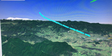
The following images are photographs from when I first ingested real-time data into the 3D IR-GIS ® MapWorld (or is that RealWorld as I have currently set in the application title-bar).
The flightaware ADS-B reception fork I used for my raspberry pi applications still provides a legacy SBS port for connection to the "Beast". I used this port 30003 to acquire aircraft by processing the messages described here http://woodair.net/sbs/article/barebones42_socket_data.htm
I initially wrote the capture code in Perl code - because I thought it would be fun to see what was happening. I very quickly wrote Java code, which was easier to integrate with JMS and provided that as part of the IR-GIS ® utility toolset.
I will explore submitting JSON requests to the webserver sometime in the future to obtain "richer" data - I just wanted to get this going to demonstrate IR-GIS ® MapWorld capabilities for my planned marketing trips.
Some example code
I actually wrote this following code in Perl to see how compact I could make the code and it was fun. (Note I am an old C++ gun and I have reluctantly written real-time code in Java, and well Perl works surprisingly well in this case too.)
The Aircraft.pm Object
# History:
# 20190908 Ralph Holland - initial writing
#
# object to contain Aircraft details

package Aircraft;

use strict;

sub new {
    my $class = shift;
    my %options = @_;

    my $self = {
        scode => 0,
        flightId => undef,
        gs => undef,
        lat => undef,
        lon => undef,
        alt => undef,
        track => undef,
        timestamp => undef,
        %options,

    };
    bless($self,$class);
    return ($self);
}

sub setSurfacePosition {

#    my ($self,$aref) = @_;

    my $self = shift ;
    my $aref = shift ;

    $self->{alt}    = $aref->[11]    ;
    $self->{gs}    = $aref->[12]    ;
    $self->{track}    = $aref->[13]    ;
    $self->{lat}    = $aref->[14]    ;
    $self->{lon}    = $aref->[15]    ;
}

sub setAirbornePosition {
    my ($self,$aref) = @_;
    $self->{alt}=@{$aref}[11];
    $self->{lon}=@{$aref}[15];
}

sub setAirborneVelocity {
    my ($self,$aref) = @_;
    $self->{gs}=@{$aref}[12];
    $self->{track}=@{$aref}[13];
    $self->{rate}=@$aref[16];
}

sub setSurveillanceAlt {
    my ($self,$aref)= @_;
    my $val ='';
    if (@{$aref}[20] eq '1') {
        $val = 'ground';
    }
    else {
        $val = @{$aref}[11];
    }
    $self->{alt}=$val;
}

sub setSurveillanceId {
    my ($self,$aref)= @_;
    my $val;
    if (@{$aref}[20] eq '1') {
        $val = 'ground';
    }
    else {
        $val = @{$aref}[11];
    }
    $self->{alt}=$val;
    $self->{squawk}=@{$aref}[17];
}

# this is a setter & a getter (using the well-known perl pattern)
sub timestamp {
    my ($self, $value) = @_;
    if (@_ == 2) {
        $self->{timestamp}= $value;
    }
    return $self->{timestamp};
}

sub setFlightId {
    my $self = shift;
    if (@_) {
        my $val = shift;
        $val =~ s/^\s+|\s+$//g;
        chomp($val);
        $self->{flightId} = $val;
    }
}
The main code piCap.pl:
#!/usr/bin/perl

# History:
# 20190908 Ralph Holland - initial writing

use lib '.';
use Aircraft;
use IO::Socket;
use Switch;
use Data::Dumper;
use strict;
use Date::Parse;
use Date::Language;


my $gRemoteHost = "10.2.1.136";
my $gPort = 30003;

my $socket = new IO::Socket::INET (
    PeerAddr=> $gRemoteHost,
    PeerPort=> $gPort,
    Proto => 'tcp'

) or die "Error in Socket Creation : $!\n";

print "Waiting for server $gRemoteHost port $gPort\n";

my %aircraft = ( );

sub capture {

    print "%aircraft\n";

    while(1) {

        my $data = <$socket>;
        chomp($data);
        my @values = split(',', $data);
        my $length = @values;
        if ($length > 4) {
            my $scode = $values[4];
            $scode =~ s/^\s+|\s+$//g;
            if (defined $scode and length $scode == 6) {

                my $type = $values[0];
                my $craft;

                if (exists( $aircraft{$scode} )) {
                    $craft = $aircraft{$scode};
                }
                else {
                    $craft = new Aircraft( scode=>$scode );
                    $aircraft{$scode}=$craft;
                }
                # Change the separators / to -
                my $genDate = $values[6];
                $genDate=~ s,/,-,g;
                $genDate = $genDate . 'T' . $values[7];

                # print "date=$genDate\n";
                my $dateTime = str2time($genDate);

                $craft->timestamp($dateTime);
                switch($type) {
                    case 'MSG' {
                        my $index = $values[1];
                        print "$data\n$type$index\n";
                        switch($values[1]) {
                            case 1 {
                                $craft->setFlightId($values[10])
                            }
                            case 2 {
                                $craft->setSurfacePosition(\@values);
                            }
                            case 3 {
                                $craft->setAirbornePosition(\@values);
                            }
                            case 4 {
                                $craft->setAirborneVelocity(\@values);
                            }
                            case 5 {
                                $craft->setSurveillanceAlt(\@values);
                            }
                            case 6 {
                                $craft->setSurveillanceId(\@values);
                            }
                            case 7 {

                            }
                            case 8 {

                            }
                            else {}
                        }
                        print Dumper($craft);
                    }
                    case 'SEL' {
                    }
                    case 'ID' {
                    }
                    else {  }
                }
            }
        }

        # Now remove stale entries
        while (my ($key, $value) = each %aircraft) {
            my $age = time() - $value->{timestamp};
            if ($age > 240) {
                print "droping aircraft=$key age=$age\n";
                delete $aircraft{$key};   # This is safe
            }
        }
    }
}

capture();
This was very easy to rewrite in Java, and to incoporate into the IR-GIS ® product suite.


