Blog

A photo with actual colours as seen from the air between Cowra NSW returning to Canberra Australia just after sunset.
iPhone 6 plus 1/17 sec f2.2 ISO-64 lat 34S43'31.55" lon 149E0'4.12" alt 5000' AMSL on 12 Feb 2017 20:11.
IR-GIS ® Product Suite
 The IR-GIS ® Intellectual Property (for real-time processing) is available under licence or sale, contact details are included at the bottom of the main ir-gis.com web-page. The IP is solely owned by Ralph Holland and is unencombered and partitioned into private wikis and repositories all ready to undergo due diligence.
IR-GIS has been trade-marked by www.arising.com.au
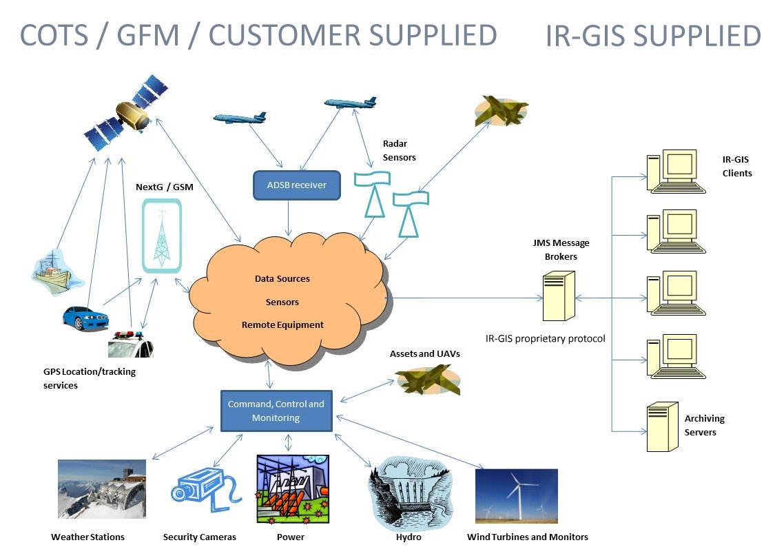
The 2.1.X Innovative Real-time - Geographic Information System (suite) includes:
- Overview of IR-GIS ® product
- Technical Specifications for IR-GIS ® product
- ir-xml real-time message formats for sensors, tracking and geodatabase storage
- IR-GIS ® MapView 2D GIS product with real-time layers provided by ir-xml input datasources
- IR-GIS ® MapWorld 3D GIS product with real-time layers provided by ir-xml datasources
- IR-GIS ® HPS real-time geodatabase recording and pullback of ir-xml datasources.
- IR-GIS ® Hps Browser - for (offline) geodatabase inspection and validation.
- IR-GIS ® piCap - for acquisition of aircraft ADS-B position reports and amplifying data
IR-GIS ® MapView has been running since 2010 and is overlayed over the famous Open Source GIS http://udig.refractions.net/ project code which has a wide development community.
utilities
The product suite uses activemq JMS Topic and Queues for its transport and command-and-control facilities for the real-time messaging (layers).
The following utilities are used to analyse or inject messages for analysis:
- CrossHatch - for load-testing and analysis
- TopicToFile - for communications engineering
- FileToTopic - for communications engineering
- others to be documented ...
See
- media:system-engineering.jpg for system engineering scenarios, or
- visit the home page http://ir-gis.com
Numerous technical designs are involved in this architecture; MapView alone contains over 30,000 Java classes. Details of the design are kept in a private-wiki. All such wikis (including this one) are instances of the mediawiki - because its the best. Mediawiki has section headers, table of contents and the best things are category:Index and other categories and features, including interwiki linking (which I use between the private wikis to prevent data duplication).
capability planning
The future of the IR-GIS product has been examined with the following capability assessment which will lead to our roadmaps, which we will publish in due course:
More later.
IR-GIS ® shortcuts
- Anouncement_MapView - new product announcement
- Overview - outlines product capabilities
- TechnicalSpec - brief product specifications
- MapView - displays 2D map and real-time track/position reports over map layers
- MapWorld - 3D real-time display and tracking with stereoscopic projection (VR) of maps.
- HPS - records real-time geo-data and text data providing text-search and pullback of real-time data for display
- Hps Browser - provides deep offline database analysis
- ir-xml - the innovative real-time message formats accepted by IR-GIS ® systems
- PiCap - acquires real-time ADS-B aircraft tracks and data from piaware receivers.
- KmlPump - can be used to feed KML track data into the activemq transport used by IR-GIS ® applications
- CrossHatch - is used to test IR-GIS ® applications with simulated aircraft tracks.
- TopicToFile - can be used for engineering communication protocols
IR-GIS ® Blog
2024
- 2024-01-28 migrated to medaiwiki LTS version 1.41.0
2020
- 2020-01-17 Enhanced the ir-xml parsing description for nested elements and attributes. Updated the description for MapWorld
- 2020-01-03 Recent fire data (will be treated as Real-time in the future) Fire Data.
- 2020-01-03 Added MediaWiki:Sitenotice this server may undergo backups and outages due to the wild-fires running down the ridge-line from Tarcutta, west of Tumut to Cabramurra See https://myfirewatch.landgate.wa.gov.au/ near Tumut/Batlow/Talbingo.
2019
- 2019-12-19 I included view port meta-data in the mediawiki for mobile devices
- 2019-12-18 http://ir-gis.com domain registered with google search console to see how my SEO ranking goes - I think this is going to be problematic - oh how the world wide web has changed since I first starting sending email in 1980.
- 2019-12-16 public release of ir-xml - the real-time messaging format; this has been kept closed since 2010.
- 2019-12-14 Work resumes on IR-GIS ® MapWorld and PiCap introduced.
- 2019-12-14 IR-GIS ® web-pages moved from old host to new http://ir-gis.com domain.
- 2018-09-20 New IR-GIS ® MapView 2.X Announcement - new 2.X baseline developed.
- 2010-01-10 IR-GIS ® Production product release.
Site Map
- see category:Index for main content index
- see category:public for all public pages (note italic pages are redirects)
- see category:Redirect for old pages and some that may have been moved external to this site.

